| Mile |
Features and Highlights |
| 0 |
Potash Boat Ramp — river right. Potash mine located just upstream — mining salt and potash used in fertilizer.
|
| 1 |
Shafer oil well site — river right. It caught fire in 1925 and spilled thousands of barrels into the Colorado River over several months.
|
| 4-6 |
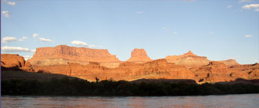
Pyramid Butte — river right |
| 8.5 |
J.H. Shafer oil well site — river right |
| 10 |
Petrified wood — river right |
| 11 |
Dead Horse Point. Early horse
thieves wrangled stolen horses up to the top of a cliff. The area
created a natural corral. Horses eventually perished from lack of
water.
|
| 11-14 |
Gooseneck — river bends forming a gooseneck turn |
| 17 |
Little Bridge Canyon — river right |
| 20 |
Lockhart Canyon — river left |
| 21 |
Horsethief Canyon — river left |
| 23.5 |
Lathrop Canyon — river right. Anasazi Culture ruins — river right
|
| 27 |
Coffee Pot Ruin — river left.
Anasazi Culture built intricate granary within this sandstone spire.
Access is difficult. Visible from the river.
|
| 29 |
Sheep Bottom — river right |
| 30.5 |
Indian Creek — river left. Ruins located up the creek along the cliff walls.
|
| 32 |
Monument Creek — river right |
| 36-40 |
The Loop — river left. River
nearly loops back upon itself. Hikers can hike up from the river on one
side and back down to it on the other. Ruins located on the hike.
Spectacular panoramic views.
|
| 43 |
Salt Creek — river left |
| 44 |
Elephant Canyon |
| 47 |
Confluence with the Green River. Inscription — Green River side.
|
| 51.5 |
Lower Red Lake Canyon — river right. Hiking trail to the Needles District.
|
| 52 |
Spanish Bottom — river right. Hiking trail to the Doll’s House — incredible rock formations within the Maze District.
|
| 53 |
Rapids 1 and 2 |
| 54 |
Rapids 3 and 4 |
| 55 |
Rapid 5 — “Surprise Rapid.” Hiking trail to the Dolls House — river right.
|
| 55-54 |
Rapids 6, 7, and 8 |
| 54-55 |
Rapids 9 and 10 |
| 56 |
Rapids 11 and 12 |
| 58-59 |
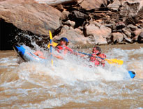
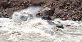
Rapids 13-18 — “ Mile Long
Rapids.” Rapid 15 — “Capsize Rapid” — Inscriptions left behind by the
Best party in 1891, after losing one boat here — river right.
|
| 60 |
Rapid 20 |
| 60-61 |
Rapids 21-23 — “The Big Drops.”
The river drops 80 feet in elevation at this point, creating three of
the most feared rapids in the canyon.
|
| 61-62 |
Rapids 24-26 |
| 63 |
Rapid 27. Imperial Canyon — river left
|
| 64 |
Rapid 28. Waterhole Canyon — river left
|
| 62.5 |
Gypsum Canyon — river left |
| 63.5 |
Beginning of Lake Powell |
| 65 |
Palmer Canyon — river left |
| 68.5 |
Clearwater Canyon — river right |
| 69.5 |
Bowdie Canyon — river left |
| 74.5 |
Cove Canyon — river right |
| 76.5 |
Rockfall Canyon — river left |
| 77.5 |
Dark Canyon — river left. Hike up
the creek bed to waterfalls and spectacular rock formations. Before the
Glen Canyon dam was built, Dark Canyon was home to one of the top 10
rapids in the nation. It was submerged as Lake Powell filled.
|
| 83-85 |
Millie Crag Bend. Sheep Canyon — river left
|
| 87.5 |
Rock Canyon — river right |
| 92.5 |
Dirty Devil River enters Lake Powell from river right. |
| 95 |
Hite marina and boat ramp on Lake Powell. |